Example of Geophysical Prospecting format
Recent searches

Example of Geophysical Prospecting format Example of Geophysical Prospecting format Example of Geophysical Prospecting format Example of Geophysical Prospecting format Example of Geophysical Prospecting format Example of Geophysical Prospecting format Example of Geophysical Prospecting format Example of Geophysical Prospecting format Example of Geophysical Prospecting format Example of Geophysical Prospecting format Example of Geophysical Prospecting format Example of Geophysical Prospecting format Example of Geophysical Prospecting format
Sample paper formatted on SciSpace - SciSpace
This content is only for preview purposes. The original open access content can be found here.
Look Inside
Example of Geophysical Prospecting format Example of Geophysical Prospecting format Example of Geophysical Prospecting format Example of Geophysical Prospecting format Example of Geophysical Prospecting format Example of Geophysical Prospecting format Example of Geophysical Prospecting format Example of Geophysical Prospecting format Example of Geophysical Prospecting format Example of Geophysical Prospecting format Example of Geophysical Prospecting format Example of Geophysical Prospecting format Example of Geophysical Prospecting format
Sample paper formatted on SciSpace - SciSpace
This content is only for preview purposes. The original open access content can be found here.
open access Open Access

Geophysical Prospecting — Template for authors

Publisher: Wiley
Categories Rank Trend in last 3 yrs
Geophysics #53 of 131 down down by 24 ranks
Geochemistry and Petrology #64 of 128 down down by 22 ranks
journal-quality-icon Journal quality:
Good
calendar-icon Last 4 years overview: 568 Published Papers | 1808 Citations
indexed-in-icon Indexed in: Scopus
last-updated-icon Last updated: 10/06/2020
Related journals
Insights
General info
Top papers
Popular templates
Get started guide
Why choose from SciSpace
FAQ

Related Journals

open access Open Access

Springer

Quality:  
High
CiteRatio: 5.9
SJR: 2.078
SNIP: 1.439
open access Open Access
recommended Recommended

Springer

Quality:  
High
CiteRatio: 7.5
SJR: 1.78
SNIP: 2.18
open access Open Access
recommended Recommended

Springer

Quality:  
High
CiteRatio: 7.8
SJR: 1.51
SNIP: 1.687
open access Open Access
recommended Recommended

Springer

Quality:  
High
CiteRatio: 11.5
SJR: 1.991
SNIP: 2.319

Journal Performance & Insights

Impact Factor

CiteRatio

Determines the importance of a journal by taking a measure of frequency with which the average article in a journal has been cited in a particular year.

A measure of average citations received per peer-reviewed paper published in the journal.

1.556

4% from 2018

Impact factor for Geophysical Prospecting from 2016 - 2019
Year Value
2019 1.556
2018 1.621
2017 1.744
2016 1.846
graph view Graph view
table view Table view

3.2

3% from 2019

CiteRatio for Geophysical Prospecting from 2016 - 2020
Year Value
2020 3.2
2019 3.3
2018 3.3
2017 3.9
2016 4.2
graph view Graph view
table view Table view

insights Insights

  • Impact factor of this journal has decreased by 4% in last year.
  • This journal’s impact factor is in the top 10 percentile category.

insights Insights

  • CiteRatio of this journal has decreased by 3% in last years.
  • This journal’s CiteRatio is in the top 10 percentile category.

SCImago Journal Rank (SJR)

Source Normalized Impact per Paper (SNIP)

Measures weighted citations received by the journal. Citation weighting depends on the categories and prestige of the citing journal.

Measures actual citations received relative to citations expected for the journal's category.

0.735

17% from 2019

SJR for Geophysical Prospecting from 2016 - 2020
Year Value
2020 0.735
2019 0.882
2018 0.748
2017 0.7
2016 1.834
graph view Graph view
table view Table view

0.905

3% from 2019

SNIP for Geophysical Prospecting from 2016 - 2020
Year Value
2020 0.905
2019 0.937
2018 1.173
2017 1.222
2016 2.045
graph view Graph view
table view Table view

insights Insights

  • SJR of this journal has decreased by 17% in last years.
  • This journal’s SJR is in the top 10 percentile category.

insights Insights

  • SNIP of this journal has decreased by 3% in last years.
  • This journal’s SNIP is in the top 10 percentile category.
Geophysical Prospecting

Guideline source: View

All company, product and service names used in this website are for identification purposes only. All product names, trademarks and registered trademarks are property of their respective owners.

Use of these names, trademarks and brands does not imply endorsement or affiliation. Disclaimer Notice

Wiley

Geophysical Prospecting

Geophysical Prospecting publishes the best in primary research on the science of geophysics as it applies to the exploration, evaluation and extraction of earth resources. Drawing heavily on contributions from researchers in the oil and mineral exploration industries, the jour...... Read More

Geophysics

Geochemistry and Petrology

Earth and Planetary Sciences

i
Last updated on
10 Jun 2020
i
ISSN
0016-8025
i
Impact Factor
High - 1.303
i
Open Access
Yes
i
Sherpa RoMEO Archiving Policy
White faq
i
Plagiarism Check
Available via Turnitin
i
Endnote Style
Download Available
i
Bibliography Name
apa
i
Citation Type
Author Year
(Blonder et al., 1982)
i
Bibliography Example
Blonder, G. E., Tinkham, M., and Klapwijk, T. M. 1982. Transition from metallic to tunneling regimes in superconducting microconstrictions: Excess current, charge imbalance, and supercurrent conversion. Phys. Rev. B, 25(7):4515–4532

Top papers written in this journal

Journal Article DOI: 10.1111/J.1365-2478.1996.TB00142.X
Rapid least-squares inversion of apparent resistivity pseudosections by a quasi-Newton method1
M.H. Loke1, R. D. Barker2
01 Jan 1996 - Geophysical Prospecting

Abstract:

A fast inversion technique for the interpretation of data from resistivity tomography surveys has been developed for operation on a microcomputer. This technique is based on the smoothness-constrained least-squares method and it produces a two-dimensional subsurface model from the apparent resistivity pseudosection. In the fi... A fast inversion technique for the interpretation of data from resistivity tomography surveys has been developed for operation on a microcomputer. This technique is based on the smoothness-constrained least-squares method and it produces a two-dimensional subsurface model from the apparent resistivity pseudosection. In the first iteration, a homogeneous earth model is used as the starting model for which the apparent resistivity partial derivative values can be calculated analytically. For subsequent iterations, a quasi-Newton method is used to estimate the partial derivatives which reduces the computer time and memory space required by about eight and twelve times, respectively, compared to the conventional least-squares method. Tests with a variety of computer models and data from field surveys show that this technique is insensitive to random noise and converges rapidly. This technique takes about one minute to invert a single data set on an 80486DX microcomputer. read more read less

Topics:

Electrical resistivity tomography (53%)53% related to the paper, Least squares (51%)51% related to the paper
2,181 Citations
Journal Article DOI: 10.1111/J.1365-2478.1989.TB02221.X
Ground-penetrating radar for high-resolution mapping of soil and rock stratigraphy
01 Jul 1989 - Geophysical Prospecting

Abstract:

Ground-penetrating radar is a technique which offers a new way of viewing shallow soil and rock conditions. The need to better understanding overburden conditions for activities such as geochemical sampling, geotechnical investigations, and placer exploration, as well as the factors controlling groundwater flow, has generated... Ground-penetrating radar is a technique which offers a new way of viewing shallow soil and rock conditions. The need to better understanding overburden conditions for activities such as geochemical sampling, geotechnical investigations, and placer exploration, as well as the factors controlling groundwater flow, has generated an increasing demand for techniques which can image the subsurface with higher resolution than previously possible. The areas of application for ground-penetrating radar are diverse. The method has been used successfully to map ice thickness, water depth in lakes, bedrock depth, soil stratigraphy, and water table depth. It is also used to delineate rock fabric, detect voids and identify karst features. The effective application of the radar for the high-resolution definition of soil stratigraphy and fractures in bedrock is highlighted. The basic principles and practices involved in acquiring high quality radar data in the field are illustrated by selected case histories. One example demonstrates how radar has been used to map the bedrock and delineate soil horizons to a depth of more than 20 m. Two case histories show how radar has been used to map fractures and changes of rock type to 40 m range from inside a mine. Another case history demonstrates how radar has also been used to detect and map the extent of groundwater contamination. The corroboration of the radar results by borehole investigations demonstrates the power and utility of the high-resolution radar method as an aid for interpolation and extrapolation of the information obtained with conventional coring programmes. With the advent of new instrumentation and field procedures, the routine application of the radar method is becoming economically viable and the method will see expanded use in the future. read more read less

Topics:

Ground-penetrating radar (67%)67% related to the paper, Radar (62%)62% related to the paper, Bedrock (54%)54% related to the paper, Geotechnical investigation (53%)53% related to the paper, Stratigraphy (51%)51% related to the paper
1,962 Citations
Journal Article DOI: 10.1111/1365-2478.12028
Specific surface area and pore‐size distribution in clays and shales
Utpalendu Kuila1, Manika Prasad1
01 Mar 2013 - Geophysical Prospecting

Abstract:

One of the biggest challenges in estimating the elastic, transport and storage properties of shales has been a lack of understanding of their complete pore structure. The shale matrix is predominantly composed of micropores (pores less than 2 nm diameter) and mesopores (pores with 2–50 nm diameter). These small pores in the s... One of the biggest challenges in estimating the elastic, transport and storage properties of shales has been a lack of understanding of their complete pore structure. The shale matrix is predominantly composed of micropores (pores less than 2 nm diameter) and mesopores (pores with 2–50 nm diameter). These small pores in the shale matrix are mainly associated with clay minerals and organic matter and comprehending the controls of these clays and organic matter on the pore-size distribution is critical to understand the shale pore network. Historically, mercury intrusion techniques are used for pore-size analysis of conventional reservoirs. However, for unconventional shale reservoirs, very high pressures (> 414 MPa (60 000 psi)) would be required for mercury to access the full pore structure, which has potential pitfalls. Current instrumental limitations do not allow reliable measurement of significant portions of the total pore volume in shales. Nitrogen gas-adsorption techniques can be used to characterize materials dominated by micro- and mesopores (2–50 nm). A limitation of this technique is that it fails to measure large pores (diameter >200 nm). We use a nitrogen gas-adsorption technique to study the micro- and mesopores in shales and clays and compare the results from conventional mercury porosimetry techniques. Our results on pure clay minerals and natural shales show that (i) they have a multiscale pore structure at different dimensions (ii) fine mesopores, with a characteristic 3 nm pore size obtained with N2 gas-adsorption are associated with an illite-smectite group of clays but not with kaolinite; (iii) compaction results in a decrease of pore volume and a reduction of pore size in the ‘inter-aggregate’ macropores of the illitesmectite clays while the fine ‘intra-tachoid’ mesopores are shielded from compaction; (iv) for natural shales, mineralogy controls the pore-size distributions for shales and the presence of micropores and fine mesopores in natural shales can be correlated with the dominance of the illite-smectite type of clays in the rock. Our assessment of incompressible 3 nm sized pores associated with illite-smectite clays provides an important building block for their mineral modulus. read more read less

Topics:

Porosimetry (55%)55% related to the paper, Oil shale (50%)50% related to the paper
874 Citations
Journal Article DOI: 10.1111/J.1365-2478.1983.TB01060.X
Migration by extrapolation of time‐dependent boundary values*
George A. McMechan1
01 Jun 1983 - Geophysical Prospecting

Abstract:

Migration of an observed zero-offset wavefield can be performed as the solution of a boundary value problem in which the data are extrapolated backward in time. This concept is implemented through a finite-difference solution of the two-dimensional acoustic wave equation. All depths are imaged simultaneously at time 0 (the im... Migration of an observed zero-offset wavefield can be performed as the solution of a boundary value problem in which the data are extrapolated backward in time. This concept is implemented through a finite-difference solution of the two-dimensional acoustic wave equation. All depths are imaged simultaneously at time 0 (the imaging condition), and all dips (right up to vertical) are correctly migrated. Numerical examples illustrate this technique in both constant and variable velocity media. read more read less

Topics:

Boundary value problem (58%)58% related to the paper, Acoustic wave equation (56%)56% related to the paper, Seismic migration (56%)56% related to the paper, Extrapolation (54%)54% related to the paper, Wave equation (52%)52% related to the paper
756 Citations
open accessOpen access Journal Article DOI: 10.1111/J.1365-2478.2004.00423.X
A numerical comparison of 2D resistivity imaging with 10 electrode arrays
Torleif Dahlin1, Bing Zhou2
01 Sep 2004 - Geophysical Prospecting

Abstract:

Numerical simulations are used to compare the resolution and efficiency of 2D resistivity imaging surveys for 10 electrode arrays. The arrays analysed include polepole (PP), pole-dipole (PD), half-Wenner (HW), Wenner-α (WN), Schlumberger (SC), dipole-dipole (DD), Wenner-β (WB), γ -array (GM), multiple or moving gradient array... Numerical simulations are used to compare the resolution and efficiency of 2D resistivity imaging surveys for 10 electrode arrays. The arrays analysed include polepole (PP), pole-dipole (PD), half-Wenner (HW), Wenner-α (WN), Schlumberger (SC), dipole-dipole (DD), Wenner-β (WB), γ -array (GM), multiple or moving gradient array (GD) and midpoint-potential-referred measurement (MPR) arrays. Five synthetic geological models, simulating a buried channel, a narrow conductive dike, a narrow resistive dike, dipping blocks and covered waste ponds, were used to examine the surveying efficiency (anomaly effects, signal-to-noise ratios) and the imaging capabilities of these arrays. The responses to variations in the data density and noise sensitivities of these electrode configurations were also investigated using robust (L1-norm) inversion and smoothness-constrained least-squares (L2-norm) inversion for the five synthetic models. The results show the following. (i) GM and WN are less contaminated by noise than the other electrode arrays. (ii) The relative anomaly effects for the different arrays vary with the geological models. However, the relatively high anomaly effects of PP, GM and WB surveys do not always give a high-resolution image. PD, DD and GD can yield better resolution images than GM, PP, WN and WB, although they are more susceptible to noise contamination. SC is also a strong candidate but is expected to give more edge effects. (iii) The imaging quality of these arrays is relatively robust with respect to reductions in the data density of a multi-electrode layout within the tested ranges. (iv) The robust inversion generally gives better imaging results than the L2-norm inversion, especially with noisy data, except for the dipping block structure presented here. (v) GD and MPR are well suited to multichannel surveying and GD may produce images that are comparable to those obtained with DD and PD. Accordingly, the GD, PD, DD and SC arrays are strongly recommended for 2D resistivity imaging, where the final choice will be determined by the expected geology, the purpose of the survey and logistical considerations. read more read less
View PDF
731 Citations
Author Pic

SciSpace is a very innovative solution to the formatting problem and existing providers, such as Mendeley or Word did not really evolve in recent years.

- Andreas Frutiger, Researcher, ETH Zurich, Institute for Biomedical Engineering

Get MS-Word and LaTeX output to any Journal within seconds
1
Choose a template
Select a template from a library of 40,000+ templates
2
Import a MS-Word file or start fresh
It takes only few seconds to import
3
View and edit your final output
SciSpace will automatically format your output to meet journal guidelines
4
Submit directly or Download
Submit to journal directly or Download in PDF, MS Word or LaTeX

(Before submission check for plagiarism via Turnitin)

clock Less than 3 minutes

What to expect from SciSpace?

Speed and accuracy over MS Word

''

With SciSpace, you do not need a word template for Geophysical Prospecting.

It automatically formats your research paper to Wiley formatting guidelines and citation style.

You can download a submission ready research paper in pdf, LaTeX and docx formats.

Time comparison

Time taken to format a paper and Compliance with guidelines

Plagiarism Reports via Turnitin

SciSpace has partnered with Turnitin, the leading provider of Plagiarism Check software.

Using this service, researchers can compare submissions against more than 170 million scholarly articles, a database of 70+ billion current and archived web pages. How Turnitin Integration works?


Turnitin Stats
Publisher Logos

Freedom from formatting guidelines

One editor, 100K journal formats – world's largest collection of journal templates

With such a huge verified library, what you need is already there.

publisher-logos

Easy support from all your favorite tools

Geophysical Prospecting format uses apa citation style.

Automatically format and order your citations and bibliography in a click.

SciSpace allows imports from all reference managers like Mendeley, Zotero, Endnote, Google Scholar etc.

Frequently asked questions

1. Can I write Geophysical Prospecting in LaTeX?

Absolutely not! Our tool has been designed to help you focus on writing. You can write your entire paper as per the Geophysical Prospecting guidelines and auto format it.

2. Do you follow the Geophysical Prospecting guidelines?

Yes, the template is compliant with the Geophysical Prospecting guidelines. Our experts at SciSpace ensure that. If there are any changes to the journal's guidelines, we'll change our algorithm accordingly.

3. Can I cite my article in multiple styles in Geophysical Prospecting?

Of course! We support all the top citation styles, such as APA style, MLA style, Vancouver style, Harvard style, and Chicago style. For example, when you write your paper and hit autoformat, our system will automatically update your article as per the Geophysical Prospecting citation style.

4. Can I use the Geophysical Prospecting templates for free?

Sign up for our free trial, and you'll be able to use all our features for seven days. You'll see how helpful they are and how inexpensive they are compared to other options, Especially for Geophysical Prospecting.

5. Can I use a manuscript in Geophysical Prospecting that I have written in MS Word?

Yes. You can choose the right template, copy-paste the contents from the word document, and click on auto-format. Once you're done, you'll have a publish-ready paper Geophysical Prospecting that you can download at the end.

6. How long does it usually take you to format my papers in Geophysical Prospecting?

It only takes a matter of seconds to edit your manuscript. Besides that, our intuitive editor saves you from writing and formatting it in Geophysical Prospecting.

7. Where can I find the template for the Geophysical Prospecting?

It is possible to find the Word template for any journal on Google. However, why use a template when you can write your entire manuscript on SciSpace , auto format it as per Geophysical Prospecting's guidelines and download the same in Word, PDF and LaTeX formats? Give us a try!.

8. Can I reformat my paper to fit the Geophysical Prospecting's guidelines?

Of course! You can do this using our intuitive editor. It's very easy. If you need help, our support team is always ready to assist you.

9. Geophysical Prospecting an online tool or is there a desktop version?

SciSpace's Geophysical Prospecting is currently available as an online tool. We're developing a desktop version, too. You can request (or upvote) any features that you think would be helpful for you and other researchers in the "feature request" section of your account once you've signed up with us.

10. I cannot find my template in your gallery. Can you create it for me like Geophysical Prospecting?

Sure. You can request any template and we'll have it setup within a few days. You can find the request box in Journal Gallery on the right side bar under the heading, "Couldn't find the format you were looking for like Geophysical Prospecting?”

11. What is the output that I would get after using Geophysical Prospecting?

After writing your paper autoformatting in Geophysical Prospecting, you can download it in multiple formats, viz., PDF, Docx, and LaTeX.

12. Is Geophysical Prospecting's impact factor high enough that I should try publishing my article there?

To be honest, the answer is no. The impact factor is one of the many elements that determine the quality of a journal. Few of these factors include review board, rejection rates, frequency of inclusion in indexes, and Eigenfactor. You need to assess all these factors before you make your final call.

13. What is Sherpa RoMEO Archiving Policy for Geophysical Prospecting?

SHERPA/RoMEO Database

We extracted this data from Sherpa Romeo to help researchers understand the access level of this journal in accordance with the Sherpa Romeo Archiving Policy for Geophysical Prospecting. The table below indicates the level of access a journal has as per Sherpa Romeo's archiving policy.

RoMEO Colour Archiving policy
Green Can archive pre-print and post-print or publisher's version/PDF
Blue Can archive post-print (ie final draft post-refereeing) or publisher's version/PDF
Yellow Can archive pre-print (ie pre-refereeing)
White Archiving not formally supported
FYI:
  1. Pre-prints as being the version of the paper before peer review and
  2. Post-prints as being the version of the paper after peer-review, with revisions having been made.

14. What are the most common citation types In Geophysical Prospecting?

The 5 most common citation types in order of usage for Geophysical Prospecting are:.

S. No. Citation Style Type
1. Author Year
2. Numbered
3. Numbered (Superscripted)
4. Author Year (Cited Pages)
5. Footnote

15. How do I submit my article to the Geophysical Prospecting?

It is possible to find the Word template for any journal on Google. However, why use a template when you can write your entire manuscript on SciSpace , auto format it as per Geophysical Prospecting's guidelines and download the same in Word, PDF and LaTeX formats? Give us a try!.

16. Can I download Geophysical Prospecting in Endnote format?

Yes, SciSpace provides this functionality. After signing up, you would need to import your existing references from Word or Bib file to SciSpace. Then SciSpace would allow you to download your references in Geophysical Prospecting Endnote style according to Elsevier guidelines.

Fast and reliable,
built for complaince.

Instant formatting to 100% publisher guidelines on - SciSpace.
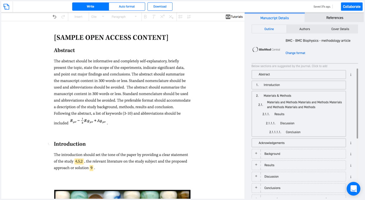
Available only on desktops 🖥

No word template required

Typset automatically formats your research paper to Geophysical Prospecting formatting guidelines and citation style.
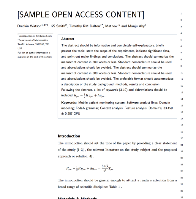

Verifed journal formats

One editor, 100K journal formats.
With the largest collection of verified journal formats, what you need is already there.

Trusted by academicians

I spent hours with MS word for reformatting. It was frustrating - plain and simple. With SciSpace, I can draft my manuscripts and once it is finished I can just submit. In case, I have to submit to another journal it is really just a button click instead of an afternoon of reformatting.

Andreas Frutiger
Researcher & Ex MS Word user
Use this template